Seward is a coastal city on Alaska’s Kenai Peninsula. It’s nestled between the mountains and the ocean with plenty of hiking trails that offer incredible views of the surrounding glaciers and fjords.
As the gateway to Kenai Fjords National Park, Seward is located 120 miles south of Anchorage, which is a 2.5-hour drive.
Seward is one of my favorite places to visit during the summer. Being so close to Anchorage, it’s easy to take a day trip from Anchorage if you want to hike in Seward.
Below, you’ll find a curated list of the best hikes in Seward that you don’t want to miss. I’ve also included a trail summary for each hike, which includes the total distance, time, elevation gain, and difficulty level.
Traditional Land: Alutiiq (Sugpiaq); (Visit Native-Land.ca to identify whose land you live, work, and play on.)
How to get to Seward
Seward is located in Southcentral Alaska. It’s 130 miles south of Anchorage and it usually takes about 2.5 hours to drive there. The drive is scenic with plenty of worthwhile stops as you follow the Seward Highway from Anchorage to Seward.
If you don’t have a car, you can get to Seward by taking the Alaska Railroad or shuttle bus. It’s also a popular cruise port for those traveling by cruise ship.
7 Best Hikes in Seward, Alaska
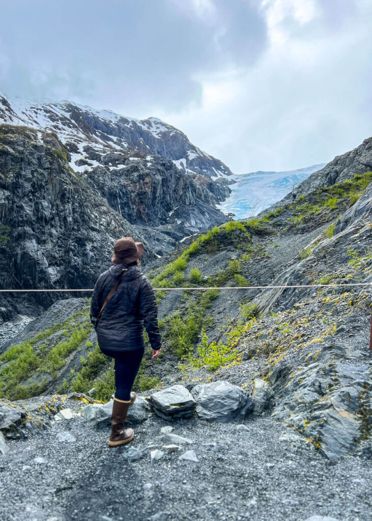
1. Harding Icefield Trail
Distance: 8.2 miles roundtrip
Time: 8 hours
Elevation Gain: 3,500 feet
Difficulty: Difficult
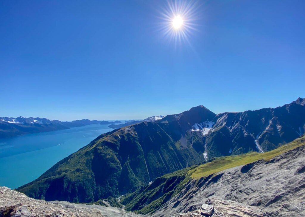
Harding Icefield Trail is one of the most popular hikes in Seward and easily one of my favorite hikes. The trail is 8.2 miles roundtrip and takes you on a climb up the valley through cottonwood and alder forests until you make it well above the tree line to a breathtaking view of a 700-square-mile ice fields.
This challenging day hike gains 1,000 feet of elevation with every mile, so some level of physical fitness is required.
The trail starts at the Exit Glacier Nature Center parking lot. This is the only land access into Kenai Fjords National Park, and the main reason the national park exists today.
If you want to explore the glacier further, it’s possible to hire a knowledgeable guide to take you onto the glacier.
How to get to Harding Icefield Trail From Anchorage:
From Anchorage, head south on the Seward Highway. Follow the Seward Highway to Seward. Turn right onto Herman Leirer Road and continue onto Exit Glacier Road. Follow the road to the end and you will see the trailhead parking.
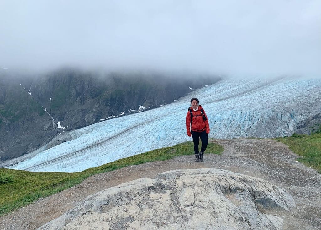
2. Exit Glacier Overlook Trail
Distance: 2.5 miles roundtrip
Time: 1 hour
Elevation Gain: 300 feet
Difficulty: Easy
Exit Glacier Trail is an easy hike in Seward with only 300 feet of elevation gain. The hike is located within Kenai Fjords National Park and it’s the perfect choice if you’re looking for family-friendly hikes that follow a well-maintained trail.
From the Exit Glacier Nature Center, you have a couple of trail options. The Glacier View Loop Trail is a one-mile loop that is also wheelchair accessible. It will take you to a viewpoint that overlooks Exit Creek and you’ll also get a lower viewpoint of Exit Glacier.
From the loop, you can follow the Exit Glacier Overlook Trail for another half mile if you want to get a view overlooking the glacier.
How to get to Exit Glacier Overlook Trail:
Follow the Seward Highway to Seward. Turn right onto Herman Leirer Road and continue onto Exit Glacier Road. Drive to the end of the road and you will see the trailhead parking.
3. Lost Lake Trail
Distance: 16 miles one-way
Time: 8 hours
Elevation Gain: 2,000 feet
Difficulty: Moderate
Lost Lake Trail is a 16-mile out-and-back hiking and backpacking trail that takes you through a temperate rainforest and follows an alpine ridge full of small lakes and vistas. You can either start hiking from the south end at Lost Lake or the Primrose Trail at the north end.
This trail is best used from June to September but you should check conditions because the trail may still be covered in snow, especially if you are staying in one of my favorite public use cabins in Seward.
I’ve hiked this trail on my own even though dense forest in bear territory. Just remember to carry bear spray. You’ll most likely encounter other people on the trail as it is popular amongst mountain bikers and trail runners.
How to get to Lost Lake Trail:
In Seward, turn right onto Scott Way which turns into Rough Drive. Turn left onto Heather Lee Lane. Turn right onto Hayden Lane. Continue to the Lost Lake Trailhead.
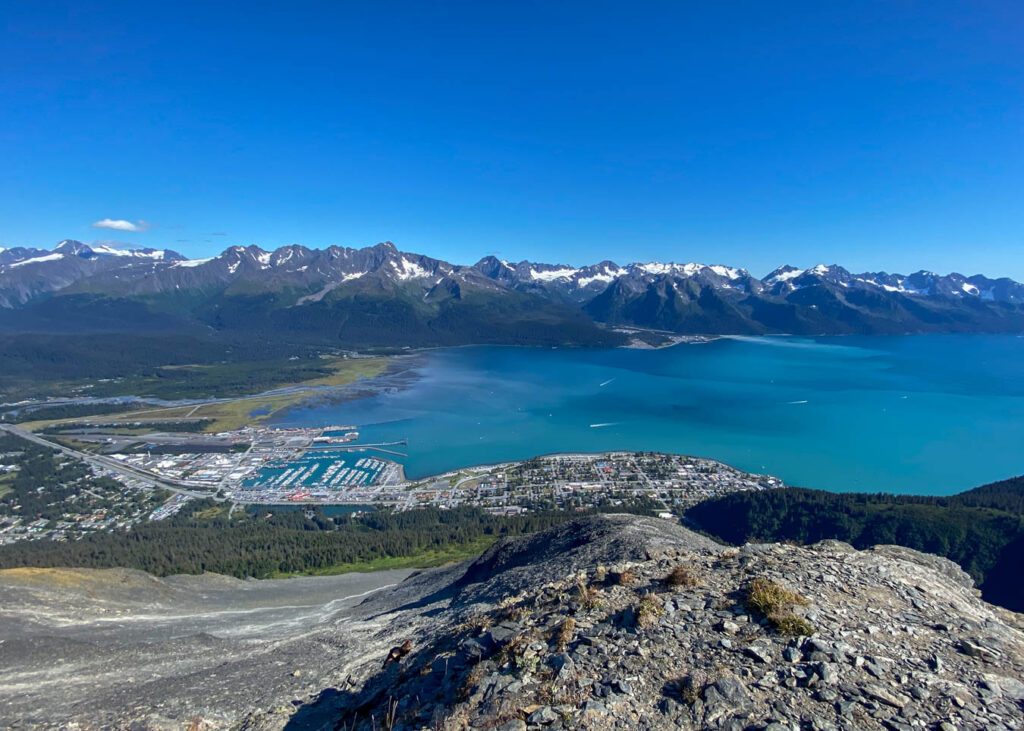
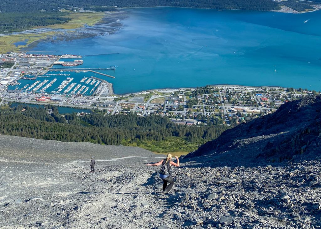
4. Mt. Marathon Trail
Distance: 4.1 miles roundtrip
Time: 3 hours
Elevation Gain: 3,022 feet
Difficulty: Difficult
Mt. Marathon Trail is considered a strenuous hike in Seward that is mostly known for being a popular mountain race. The race takes place around the Fourth of July and finishing it requires a certain skill level.
There are two recommended trails to the top of Mount Marathon, the Hikers Trail and the Jeep Trail. I’ve only hiked the Hikers Trail, which was very steep and rocky. I was amazed at the panoramic views of Resurrection Bay from the summit. On the way down, you will have to slide down loose scree, which can be scary for some hikers.
The Jeep Trail is longer but has a gradual increase in elevation as you follow the trail. The trail has more benches to sit and rest and ends in the Mt. Marathon Bowl.
How to get to Mount Marathon Trail in Seward:
Follow the Glenn Highway to Seward until Mile Post 147. Turn right towards the Byers Lake Campground.
5. Caines Head Trail
Distance: 9 miles roundtrip
Time: 4 hours
Elevation Gain: 200 feet
Difficulty: Easy
Caines Head State Recreation Site has a coastal path that will take you from Lowell Point to Derby Cove, North Beach, Fort McGilvray, South Beach, and Rocky Point. Caines Head Trail from Lowell Point to North Beach is about 4.5 miles one-way but you can hike to other points of interest beyond it.
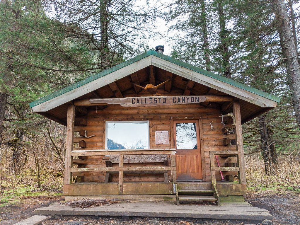
To hike to Caines Head, you need to know how to time your trip around Seward tides because it can only be accessed at low tide. Plan for a full day out hiking or plan to spend the night at one of the public use cabins along the trail.
How to get to Caines Head Trailhead:
Once you reach Seward, continue along the highway through the end of town before taking a right on Lowell Point Road. Take a left on Border Ave. and take a right on Pinnacle View Rd. Tonsina Point State Recreation Site will be on your right.
6. Tonsina Creek Trail
Distance: 4.2 miles round trip
Time: 2.5 hours
Elevation Gain: 750 feet
Difficulty: Easy
Tonsina Creek Trail is another short hike in Seward that takes you to a beautiful beach with a creek, a petrified forest, and another public use cabin.
The hike to Tonsina Point is only 4.2 miles roundtrip and it will take you about 2.5 hours to complete. There is elevation both ways as it climbs along the side of the mountain and drops down towards the beach.
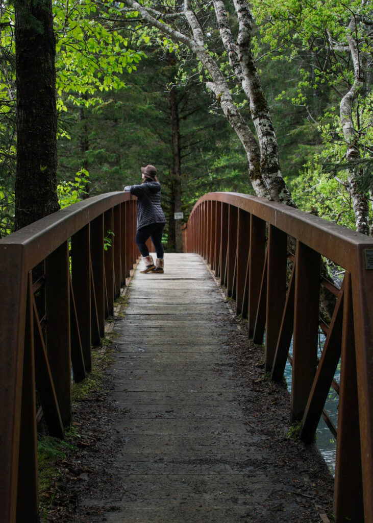
The trail is a local favorite and can be accessed year-round. There is a cute wooden bridge that crosses over Tonsina Creek, and I love taking pictures here.
From Tonsina Point, you can continue hiking toward Caines Head State Recreation Area.
How to get to Tonisna Creek Trailhead:
The Tonsina Creek Trailhead also starts from the Tonsina Point State Recreation Site.
7. Bear Mountain Trail
Distance: 5.6 miles round trip
Time: 2.5 hours
Elevation Gain: 4,300 feet
Difficulty: Very Difficult
Bear Mountain is said to be a technical and very difficult climb. There is a lot of exposure and some scrambling is required so it’s not a good hike for anyone that is not sure-footed.
Even though the hike is less than 3 miles one way, it has a lot of elevation gain! But if you don’t want to go all the way to the summit of Bear Mountain, you can hike to the Little Bear Overlook, which is about 1,500 feet lower in elevation.
Along the trail, you should expect to encounter muddy trails and overgrowth. The views from the top look amazing and I’m looking forward to hiking this mountain one day, but when I do I’ll make sure that the weather is clear and dry.
How to get to Bear Mountain Trail:
In Seward, the Bear Mountain Trail starts from the north side of 1st Ave and Jefferson Street.
Happy hiking!
Other Hiking Trails in Seward
Other hiking trails in Seward are Bear Lake, Mt. Alice, Meridian and Grayling Lake, Two Lakes Trail, Resurrection River Trail, Troop Lake Trail, and sections of the Iditarod National Historic Trail – Southern Trek (INHT).
Pin For Later

Do you have any questions about the best hiking trails in Seward, Alaska? Leave them in comments.